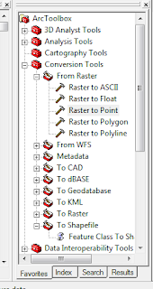
So..here's a fun thing. What if you want to do a pretty complicated operation in ArcMap mathematically. Perhaps something that would be pretty annoying to do using Raster Calculator (which is annoying itself when the syntax of the map is strange). Well, why not just export the file as an XY table and mess with your Z and then re-import it.
How do I do this is 9.3.1? Well first, you want to find your raster you want to work with and you are going to use the Conversion tools to go from Raster to point.
Now you should generate a shapefile using this that has the value you want from your raster (NOTE THAT YOU CHOOSE THE VALUE YOU WANT IF YOU HAVE MULTIPLE INFORMATION IN YOUR RASTER!!) stored as a point. In a sense, you've just gone from the field data model to a set of regularly distributed object data models (features in this case who are part of a geo-relational shape file).
Look at me using those big ArcWords from school. Would you like some ArcFries with that?
Right. now in your tool box you need to go to Data Management tools, features, Add XY coordinates. If DM tools won't open up on the menu go tools> extensions and make sure you have it enabled.
What a great tool! One input!
And there's your output, which under options you can export as a table or Database file. Manipulate as you see fit, and then you will add it back to your map later! Which I will also discuss...later!


No comments:
Post a Comment