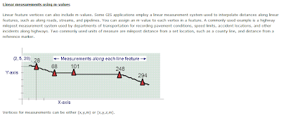
ESRI's got a pretty clear explanation of xyzm construction.
To me it was a big discovery that elevation, like any other thing you might measure at a place, is an attribute of the location, and not part of the location itself. Did you know that if you mapped xy for every location in the world at a 1 km2 scale, you would need 10 Gb of computer space?-- that's right, two integers (well more if you are thinking in binary like the computer does) for all the world... 10 Gb!
Did you know that we only see something like 2 x 10-13 of the world with our own eyes and only live for 1.4 x 10⁻⁸ of its duration? Such I learned in class. That's an awfully small world. And yet we still get lost.

No comments:
Post a Comment